Are you curious about how high you really are when you’re hiking a mountain, flying a drone, or just standing in your backyard? Measuring altitude might sound complicated, but it’s easier than you think—and knowing how to do it can give you a whole new perspective on your surroundings.
Whether you want to check the height of a peak, figure out your elevation for safety reasons, or just impress your friends with cool navigation skills, this guide will walk you through simple, effective ways to measure altitude. Stick with me, and you’ll soon discover the tools and tricks that make altitude measurement straightforward and reliable.
Ready to find out exactly how high you are? Let’s get started!
Credit: www.outdoors.org
Altimeters And How They Work
Altimeters are tools used to measure altitude, which is the height above sea level. These devices help pilots, hikers, and adventurers know their exact elevation. Altimeters work by detecting changes in air pressure or satellite signals. Understanding how altimeters function makes it easier to use them properly and read their measurements accurately.
Types Of Altimeters
There are two main types of altimeters: barometric and GPS-based. Each type uses a different method to calculate altitude. Barometric altimeters measure air pressure changes, while GPS altimeters use signals from satellites. Both types provide useful altitude data for different activities and conditions.
Barometric Altimeters
Barometric altimeters measure altitude by detecting air pressure. Air pressure drops as altitude increases. The altimeter senses this pressure change and converts it to an altitude reading. Pilots commonly use barometric altimeters because they provide real-time altitude changes. These altimeters need regular calibration to adjust for weather and pressure changes.
Gps-based Altimeters
GPS-based altimeters calculate altitude using satellite signals. The device receives signals from multiple satellites to determine its location and elevation. These altimeters are common in smartphones and hiking devices. GPS altimeters work well outdoors but may have reduced accuracy in dense forests or tall buildings. They do not require calibration like barometric altimeters.
Using Online Tools For Altitude
Using online tools to measure altitude is simple and quick. These tools use maps and GPS data to show elevation above sea level. You do not need special equipment or skills to get accurate results.
Many websites offer free services where you can click on a map or enter coordinates. They then display the altitude of that location instantly. These tools are helpful for hikers, travelers, and anyone curious about height or elevation.
Free Map Tools Elevation Finder
Free Map Tools Elevation Finder lets you find altitude by clicking anywhere on the map. It shows the exact elevation in feet or meters. The interface is easy to use and works on mobile or desktop devices. You can search for any place or zoom in to get precise data.
Daft Logic Elevation Maps
Daft Logic Elevation Maps offer a simple way to check altitude. You click on the map or enter an address. The tool then displays the elevation and other map details. It uses reliable geographic data to ensure accuracy. This site is popular for quick altitude checks.
Google Maps Terrain View
Google Maps has a Terrain View option that shows elevation changes visually. You can see hills, mountains, and valleys on the map. By moving the cursor or tapping a spot, you get the altitude at that point. This method is great for understanding the landscape around you.
Whatismyelevation Website
WhatIsMyElevation is a website that shows your current altitude instantly. It uses your device’s GPS to find your exact location. The site then displays the elevation above sea level. This tool is perfect for quick altitude checks during outdoor activities.
Mobile Apps And Devices
Mobile apps and devices offer easy ways to measure altitude on the go. They provide quick and reliable data for hikers, travelers, and outdoor enthusiasts. These tools use technology like GPS and built-in sensors to determine your height above sea level. Using apps and devices can save time and provide useful information without heavy equipment.
Gps And Mapping Apps
GPS and mapping apps use satellite signals to find your altitude. Popular apps like Google Maps and specialized altitude apps show elevation clearly. These apps work well in open areas with a clear sky view. Some apps also offer offline maps for use without internet. They display altitude along with your exact location on the map.
Abc Watches With Altimeter
ABC watches combine altimeter, barometer, and compass features. The altimeter measures altitude using air pressure changes. These watches are lightweight and perfect for outdoor activities. They provide real-time altitude data right on your wrist. Most ABC watches also store altitude history for tracking progress.
Calibration Tips For Accuracy
Calibrating your device improves altitude measurement accuracy. Start by setting the altimeter to a known altitude, like a sign or map point. Regular calibration is needed as air pressure changes affect readings. Check calibration before starting your hike or trip. This simple step ensures more reliable altitude data from your device.
Manual Methods For Measuring Altitude
Manual methods for measuring altitude have been used for centuries. These techniques rely on basic instruments and mathematical principles. They help measure height above sea level without modern technology. Many explorers and surveyors still use these methods for accuracy and simplicity.
Manual methods require skill and patience. They involve taking precise measurements and calculations. These methods are useful in remote areas where electronic devices may fail. Understanding them helps appreciate how altitude was measured before digital tools.
Using A Theodolite Or Angular Instrument
A theodolite measures angles between points on the ground and sky. It helps determine altitude by calculating vertical angles. First, set the instrument on a stable base at a known location. Aim the theodolite at the top of the object or mountain to measure its angle.
Next, measure the horizontal distance to the base of the object. Use trigonometry to find the height by combining angle and distance. This method requires clear visibility and a good line of sight. It is accurate for moderate distances and heights.
Triangulation Techniques
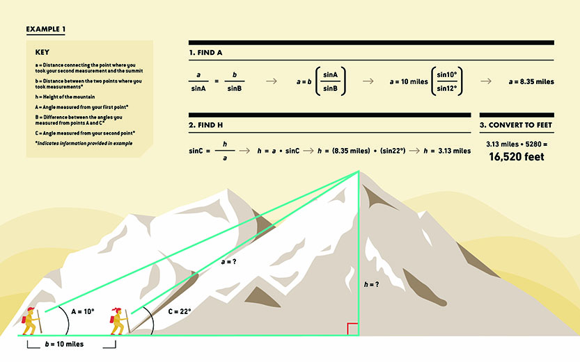
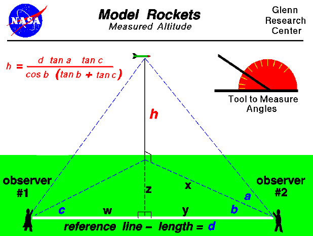
Triangulation uses geometry to find altitude by forming triangles. Surveyors measure angles from two or more known points toward a target. The points must be a measured distance apart. By calculating the angles and base length, the height of the target is found.
This method allows measurement of tall objects or terrains that are hard to access. Triangulation is precise and widely used in mapping and surveying. It depends on accurate angle readings and known baseline measurements.
Measuring Mountain Elevation
Measuring mountain elevation manually involves combining angle measurements and distance estimates. First, measure the angle from a known point to the peak. Then, measure or estimate the horizontal distance to the mountain base. Apply trigonometric formulas to find the mountain’s height above sea level.
Surveyors may repeat measurements from different spots to improve accuracy. Manual mountain elevation measurement is challenging but effective. It requires patience, clear weather, and reliable tools like a theodolite or compass.
Altitude Measurement In Aviation
Altitude measurement in aviation is crucial for safe flight operations. Pilots rely on precise altitude data to avoid collisions and maintain proper flight paths. Altitude affects aircraft performance and navigation decisions. It also ensures proper separation between aircraft in crowded airspace.
Different methods and terms describe altitude in aviation. Understanding these helps pilots and air traffic controllers communicate clearly. Two important concepts are flight levels and the distinction between pressure altitude and density altitude.
Flight Levels Explained
Flight levels are standardized altitude measurements used above a certain height. They are based on atmospheric pressure, not true altitude above sea level. Flight levels help maintain safe vertical separation between aircraft.
Each flight level corresponds to a pressure altitude measured in hundreds of feet. For example, FL350 means 35,000 feet pressure altitude. Pilots set their altimeters to a standard pressure setting to use flight levels.
This system avoids confusion from local air pressure changes. Flight levels provide a consistent reference during high altitude flights. Air traffic control assigns flight levels to organize the flow of traffic efficiently.
Pressure Altitude Vs Density Altitude
Pressure altitude is the altitude indicated when the altimeter is set to standard pressure. It reflects the height above the standard pressure surface of 29.92 inches of mercury. Pilots use pressure altitude for performance calculations and flight planning.
Density altitude adjusts pressure altitude for temperature and humidity effects. It indicates the air density and how it affects aircraft performance. Hot, humid conditions raise density altitude, reducing engine power and lift.
Understanding the difference helps pilots predict aircraft behavior. Density altitude is critical during takeoff and landing at high elevation airports. Pilots calculate both to ensure safe and efficient flight operations.
Advanced Techniques And Tools
Advanced techniques and tools help measure altitude with greater accuracy. These methods go beyond simple GPS readings or basic altimeters. They use precise sensors and modern technology to track elevation changes in real time. Such tools are useful for hikers, pilots, and engineers who need exact altitude data.
High Precision Altimeters
High precision altimeters offer very accurate altitude readings. They use sensitive pressure sensors to detect small changes in air pressure. These changes correlate to elevation differences. Some models can measure altitude changes as small as a few centimeters. They often include temperature compensation to improve accuracy. Pilots and surveyors rely on these altimeters for safe navigation and mapping.
Arduino-based Altitude Measurement
Arduino microcontrollers can measure altitude using sensors. You attach a barometric pressure sensor to the Arduino board. The sensor reads air pressure and converts it into altitude data. This DIY method is cost-effective and customizable. Users can program the Arduino to log data or display readings on a screen. It’s a popular project for hobbyists and students learning electronics.
Using Barometric Pressure And Temperature
Barometric pressure changes with altitude. Measuring this pressure helps estimate elevation. Temperature affects air pressure, so it must be considered. Combining pressure and temperature readings improves altitude accuracy. Instruments use formulas to calculate altitude from these values. This method is common in handheld devices and weather stations. It provides reliable altitude measurements even without GPS signals.
Practical Tips For Accurate Results
Accurate altitude measurement depends on careful preparation and attention to detail. Simple steps can improve your results significantly. These practical tips help ensure the data you collect is reliable and precise. Follow these guidelines to avoid common errors and get the best readings.
Calibrating Devices
Always calibrate your altimeter or GPS device before use. Calibration adjusts the instrument to current conditions. Use a known elevation point or sea level as a reference. Check the device manual for specific calibration instructions. Calibrating ensures your device reads true altitude values. Repeat calibration regularly during long trips to maintain accuracy.
Considering Weather And Atmospheric Conditions
Weather affects altitude measurements, especially with barometric altimeters. Changes in air pressure can cause errors. Measure altitude in stable weather for consistent results. Avoid taking readings during storms or rapid weather shifts. Temperature also influences barometric readings. Note the weather conditions when recording altitude data.
Verifying Altitude With Multiple Methods
Use more than one method to confirm altitude readings. Combine GPS data with barometric altimeter measurements. Check your results against topographic maps or online elevation tools. Comparing multiple sources helps detect errors early. It builds confidence in the altitude figures you report. Verification is key for critical or scientific measurements.
Credit: www.grc.nasa.gov
Frequently Asked Questions
How Do You Measure Your Altitude?
Measure altitude using an altimeter, GPS device, or smartphone app. Altimeters use air pressure, while GPS calculates height above sea level. Online maps like Google Terrain also show elevation data accurately.
Can I Measure Elevation With My Phone?
Yes, you can measure elevation with your phone using GPS-based apps like My Altitude. Some apps also use barometric sensors for accuracy. Online tools and mapping apps like Google Maps provide elevation data by location. Regular calibration improves barometric readings.
Is 500m Altitude High?
An altitude of 500 meters (1,640 feet) is considered moderate, not very high. It is common for hills and small mountains. Most people do not experience altitude sickness at this height.
Is 29.92 Pressure Altitude?
29. 92 inches of mercury (inHg) is the standard pressure setting at sea level, not pressure altitude itself. Pressure altitude is the altitude when the altimeter is set to 29. 92 inHg. It helps pilots determine true altitude under standard atmospheric conditions.
Conclusion
Measuring altitude is easier than it seems. Use tools like altimeters or GPS apps. These devices provide quick and accurate height readings above sea level. Understanding altitude helps in hiking, flying, and weather prediction. Always choose the method that fits your needs best.
Practice measuring altitude to gain confidence. With simple steps, you can track elevation anywhere. Stay curious and keep exploring new heights!